Durness.org THE PAST AND PRESENT OF DURNESS
Loch Croispol Schoolhouse
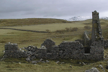
The ruins of the old parish school, the former Established Church School, remain on the shores of Loch Croispol was built in 1766 by the Scottish Society for the Propagation of Christian Knowledge, set up in 1709 and aimed to establish schools in the Highlands and Islands in order to promote Christian learning and to help stamp out Roman Catholicism and Gaelic to provide education for local children it is said to be the site of the first free school in Scotland that served the township of Balnakeil up to the notorious clearances. In 2010 funding totalling £68000 was received from Historic Scotland, Highland Legacy Fund and Heritage Lottery to research the school and surrounding area.


The little known history gives a fascinating insight into education and society in the Highlands in the 18th Century and early part of the 19th Century. The schoolhouse is an interesting site it’s in own right. There was a great deal of potential to research the school house further – both by researching SPCK and other archival material and by investigating the structure itself to see if light can be shed on how it may have looked and functioned when it was complete. Archaeologists were commissioned to undertake limited archaeological excavation to shed more light on how the schoolhouse might have looked and functioned when in use as a school
The Loch Croispol area is scattered with remains from different periods and although it is a particularly rich archaeological landscape, the types of features you see here can also be seen in variety of other locations around Sutherland. Over a 2 year period (2009 – 2010) a team of academics, local experts and interested volunteers investigated the history and archaeology associated with this rather unusual Schoolhouse in the parish of Durness.
The study area which extends north from the Kyle of Durness to Balnakeil Bay is an area of Durness Limestone. That means it is a very fertile corner of Mackay Country so not surprisingly there are a number of ancient remains such as hut circles, a chambered cairn and old homesteads already identified.
Archaeological excavations in the Loch Borralie area in 2004 and 2005 revealed buildings of late medieval origin. This work yielded evidence of the sites being reused from the Norse period through into the 1600s. Pottery shards, a spindle whorl and pieces of worked red deer antler reveal early industry, Norse links and later trading links.
The work focused on a later period from the mid 18th into the late 19th centuries and has revealed evidence of what are often called ‘pre-clearance’ settlement and landuse patterns – patterns from before the creation of the crofting system and associated settlement patterns with which we are so familiar today. The current townships were laid out in the course of the early 19th century and are organised in a very different way socially and spatially from the previous tenure system.


