Durness.org THE PAST AND PRESENT OF DURNESS
Loch Croispol Schoolhouse
Durness Parish School
The West gable
September 2009
A summary of a conversation after the archaeology with Ally Becket, Graham Bruce, Ian, Olivia Lelong and Ronnie Lansley pointing out various features and finds, and a reflection on how the archaeology proceeded, what was discovered against expectations and where we’ve reached.
One of the many motivating details regarding this archaeological phase is that very few expectations have been met, they’ve been exceeded, in almost every sense, because in every area that has been looked at, trenching inside and outside the school, nothing has quite happened the way we expected them to happen, and one remarkable observation inside the school is the fact that we’ve got so much going on! We’ve got layers of floors; with different escapades happening. There is a sense of finding where money’s been spent on the school, and when it’s been spent. We are sure we’ll be able to tie some of that together, and be able to confirm the fact that renovations have been made, money’s been spent and fit these into a timeframe. Finds have included artefacts which relate to school, the bits of slate, the little stylus, and the inkpot. There were surprises outside, the arrowhead just that little hint of something thousands of years before the school, which has survived in the soil. It may have come from somewhere else, it may have been there originally, but just that little glimpse of pre-history in Durness is lovely to see. We’ve answered lots of questions inside the school, but we’ve also raised a few questions about what’s going on more widely as well. We’ve got a building with two fireplaces one at either end. The one in the east end is a much, much smaller fireplace and in a small fireplace it is actually difficult to burn peat but with a big fireplace in the west end, burning peat would be no problem. Children brought peat to school – that was part and parcel of their payment and that’s recorded throughout Scotland, and if peat is to burn effectively, there has to be a reasonably big fireplace. The west end gable is ideal while the east end fireplace is more for burning coal and we got peat ash, as well, in the big fireplace.

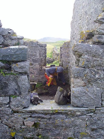
The Parish School looking North West


It’s suggestive that the west end was actually the schoolroom. Although there’s peat ash in the east end, and the east end hearth was remodelled and made smaller. It was originally bigger. This would lend itself to the idea about swapping around the use of the ends of the building during its life. That’s important because we do have this change and the evidence we’ve got for the split of the rooms – we’ve got the later phase where the smaller room is on the west side, when in the earlier phases the split’s on the east side of the door. We may be missing something about the third room, which may have an impact on that. There may be an indication that things could have changed round including the size of the rooms and what they were used for.
West Gable Fire Place

East Gable It’s also interesting the way the east end has sunk, the floor, if there was a lot of people using that room, there’s more pressure on it, the more it sinks, and possibly that was originally the schoolroom, and they moved the schoolroom to the west end simply because of all the pressure, that usage on the east end, Who knows? And possibly because the east end gable was about to fall in! It’s interesting in terms of the east-west splitting up of the building - different uses at either end but also very different builds, with very different techniques in both ends for stabilisation. The west end, which drops away where stones were piled in, and then the building built with possibly foundations. It’s, coursed on the west end it looks a nicer build. The east end’s quite different and we’ve seen a turf layer right beneath the stones which looks like the wall’s just been built directly on top of the turf, we haven’t seen anything like that at the west end at all. This creates curiosity about the builders, who were brought in to build. There’s an impression in the 1764 entry in the Session Book implying that the building wasn’t finished. The Reverend Murdo MacDonald pressed for the building and the whole aspect of education in Durness, and he died in 1761. Was the building under construction before he died? There wouldn’t have been local builders, who were capable of building that kind of construction, and maybe Murdo MacDonald brought in builders from Ross-shire or from Caithness, then he took ill and there was no incentive to keep pursuing construction. Perhaps it was partially built, he died, and then in 1764 the Kirk Session relied on local builders to construct the east end. Local builders wouldn’t have had the same expertise, certainly lime mortar to build up the walls, and maybe we had a situation where construction was carried out by two entirely different groups of builders. In the north wall, where the facings actually collapsed, there’s no mortar between the stones– it’s sort of sandy silt. There may be a little few flecks of mortar but hardly any at all. It’s hard to tell whether it’s fallen in; the stones aren’t mortared together, they’re kind of packed in.
There’s quite a skill in making lime mortar, because lime mortar is a process. There’s heat involved, and builders would require having that knowledge. Despite the fact that there is a huge quantity of lime in the local area, and apart from the significant buildings pre-Clearance like Balnakeil House, the Manse and the Factor’s house, everything else is drystane built. The local expertise was for drystane building. It’s interesting in the way that the east gable has got lime mortar in it, maybe, if this building had progressed, they’d run out of money – because the Church never has enough money, even historically and present day! This building has certainly been substantial and it’s been there a long time. Was this the first building on that site or was there anything there previous to the school? There is no any evidence of there being anything, putting aside the Neolithic find, the location in terms of; it’s a central location of that period; suggests that it’s been a vacant plot of land which is not an ideal plot of land, and obviously required a bit of work be able to build on. In fact to build it up and re-work the land, it doesn’t lend itself to other buildings, There’s nothing in the archaeology trenches we’ve opened that’s shown that it’s an older site of something. Speculate, on this arrowhead. Where did it come from, what would the environment have resembled round Croispol in the Neolithic times? We could be looking at perhaps a zone between tree and loch and, where water and forest come together, hazel, Rowan, birch, we are just of out of the oak zone the furthest north oak is found in Assynt, at Lochinver,. With the present day reduction in sheep numbers on Keoldale Farm, its noticeable on the other side of Loch Croispol there’s several stands of hazel beginning to appear. They’ve survived in the limestone, and grew up through cracks in the limestone, and there’s obviously sufficient depth of soil in the limestone cracks to have sustained this hazel, despite the sheep grazing. There’s a quite a big stand over at Borralie and the hazel has obviously managed to survive in those cracks, always cropped off, but because the sheep are off that land at Croispol and it’s now cattle, cattle ain’t interested in cropping hazel, and it’s actually now up to a metre high, that’s an indication that hazel certainly grew in the area. Picture of hazel growing on Limestone cracks around Borralie. The bog area to the south which looks like it may have been a loch and, whether there might be a depth of material there that might lend itself to coring or, there could be prehistoric deposits there which The locality was likely, scrubby woodland, a place where the arrow-head fits into a place where hunting, fishing was carried out. It was also interesting that we got that flake of chert, which suggests that people were actually working with chert, a flint-like substance. Smoo Cave shows some good examples of chert. The end of the Loch is quite sheltered that sort of bowl of land that actually very sheltered from the south-west, and it’s an ideal place for some sort of settlement, for some encampment at that end of the loch.


The bog area to the south which looks like it may have been a loch Loch Croispol has been dammed up, and is higher than it was historically. If the Loch was lower, then there would be more flow in the river there, so the area behind the schoolhouse which is currently marshy might not have been so marshy as there would have been more flow in the river, so it would have been a fasterflowing river and perhaps wider. The water’s not getting dammed up so much, therefore flowing through more with the possibilities of a lot of additional flooding. The whole level marsh area beyond the school is fascinating, because it’s very flat and with reference to the Pont map, that shows two lochs draining into Balnakeil Bay. We presumed that it was Loch Borralie and Loch Croispol. But maybe it could well have been a loch beside the school and – maybe it’s Loch Croispol and this “vanished” loch, perhaps drained, that Pont recorded on the map. The sides of the valley died down and then this flat was the vestiges. That could have happened in prehistory or the last 300 years. The burn coming out of that flat area is actually incredibly deep, and it’s obviously been ditched in – presumably the 19th century, and that’s acutely lowered the level of whatever was beyond. So, if Loch Croispol was lower, maybe that whole marshy area was a loch, and there was just a fast-flowing river between the two lochs. Prehistorically, if there was a loch, there could be all sorts of nice organic material in lower soil depths. In terms of the bridge, the only indicator as to the location is actuality the path down, and estimating the size and width of the river would be – maybe make an educated guess, whatever stream or river was there was bigger than the little canalised drainage ditch which is there now, deep as it may be, it’s not big enough to warrant the problems caused and the money spent. It would be interesting to know when that area was actually drained. There are stories about an area just as you leave Durness, heading south, that has been drained or attempted to be drained, and that local story is that it was drained by Irish navvies. Apparently, after the Caledonian Canal was built, there was a huge influx of Irish navvies in the Highlands, looking for work, and there was all nature of drainage works carried out. This would be around the 1820s. The story about the Cow Park and the drainage scheme, fitted into that period. It is possible there could have been a lot of drainage work going on in Durness, in that early 19th century period and that might fit in with the area which has obviously changed topographically because of various man-activities: drainage and redirections of waterways. The school was fairly central to the feeding localities, the surrounding townships. Knockbreck was presumably a very busy township and the children came from Balnakeil, Durine, and from Borralie and would have served this area of the parish. Locally this was always described as a parish school, but in reality it served the immediate locality, given the size of Durness. Children may have walked one or two miles, it is very unlikely to have served people from the West Moine, from Eriboll and Hope. Given there was settlement by that period right to the head of the Kyle of Durness. It’s also credible only the middle-class layer of society would be affording education. This was prior to the whole society education. Forty-five children were recorded attending in the 1790s, reflecting quite nicely the middle-class society at the time given there was quite large families. It’s probably not that many families that were actually attending school, although that would depend on the wealth and, if it was just the sons or would daughters to go for education. Considering the number of townships within reasonable walking distance, that probably represents the tacksmen level who rented the farms, that of middle-class level. Forty-five children is probably quite representative of that middle-class society, who had the money to send their children to school. The landscape pre-Clearance was different, plainly there was no sheep cropping growing plants right down to absolutely nothing. Bracken was absent, and a lot more people present. Knockbreck would have been quite a central part of what we understand is Durness now. Knockbreck is interesting because it lasted until the 1840s, when everything else had been cleared in the vicinity, Knockbreck was still there as mention was made in the 1841 Census but some time after the Kirk Session record book recorded the area had been enclosed to create the Glebe, and everybody at that point had moved. Knockbreck must have been a fairly important community to survive beyond the general Clearances in Durness in the 1830s.
How does the Archaeology depict the building?
Four trenches were opened up inside the school all connected together. What we tried to do was open up either end of the structure to have a look around the fireplaces, the business end, of both rooms, and try to get a feel for those rooms. In both of those areas we picked up very different deposits. This is when the rooms become important with the different décor of the rooms.

The East gable with the former manse in the background. The Balnakeil Craft Village can be seen just to the left of the manse.

The cleared eastern end –


At the east end we’ve got the plaster walls and timber floor, plaster ceiling in the latest phase, whereas at the west end we’ve got the clay floor and the big fireplace. These two sides have been tied together by a long trench that we put across the middle and in that trench we’ve picked up the evidence for a room division, showing the early phases of use. There are divisions of rooms on the east side of the doorway, whereas in the later phase it’s on the west side. Another trench was opened to give a peek at the doorway, to try and see exactly what’s going on in terms of the levels of the threshold, because there might be some interesting things going on with the relative floor levels at either side. There were points, that did not look quite right, especially with the levels of thresholds; It appears there was a step in, which is a bit strange. That’s quite unusual, to step down into a building but it may be that we’re missing the timber floor, so maybe entrance was on to a timber floor because it’s the latest phase or maybe flagstones, that might well have been lifted. There is a threshold stone under the exposed one. Flagstones could have gone in the same way of the timbers and it appears many of the useful stones have been taken from the building.
Part of the reference from a local point of view is places like Arnaboll, on Loch Hope, which is certainly an early 19th century building and as you walk into Arnaboll, there is flagstone in the east end and flagstone in the lobby, the corridor, but wooden floors in the small room at the back and the west. At Ceannabeinne flagstone floors are found. Flagstone was not unknown in this area. In fact, there is schist at Faraid Head that splits into flagstone, and there’s also the big flagstone deposit over at Melness, with records of that being brought round for the Manse and the Manse buildings, the now demolished farm buildings. In the schoolhouse we have found no evidence of flagstones
Was there a second floor, was there a loft, and was there an attic?
There was a space there which may have been used, we’ve got a ceiling at one end of the building recognised because of the way in which this plaster had fallen down – if we’ve got a ceiling there, there would be a space above it. The other end may have been open; and may have had rafters; it is possible there was space which could have been used for storage but, this is purely speculating. We do have a record of a skylight being installed. Church records account for the provision of a skylight, which does imply that there is possibly a second floor. Returning to the example at Arnaboll, which is possibly the oldest complete building in the whole of the parish, at one end there’s no attic, because the room goes up into the ceiling space, and there’s an attic at the other end. It is possible a skylight may have simply provided more light to one big room. Even though it doesn’t have a roof or anything, the west end of the building is obviously darker than the other end. There are the two windows, but, with the roof on it’s imaginable that this end would be quite a dark space. Perhaps the skylight would be put in there to allow the children to see to write on their slates and dip in their inkwells. In terms of rooms, because we found the end of the floor at the west end, there are divisions but perhaps expectations were they would be more clearly defined, possibly, that we might find the alcove where the staircase went up. One of the things which have masked these divisions has been the fact that most of them have been made out of timber, and the timber’s been, removed from each phase of construction perhaps reused. One of the best divisions was the little trench with some stones in it which looked like a foundation for an internal wall. But then that tells a story as well, to do with the way in which people saw the value in these building materials. The whole thing’s told a much more complex story than visualised. We’ve got a historical record and the fact that the historical record ties in with the archaeology these records show expenditure in the 1790s and the old Statistical Accounts recording the schoolroom will be in good order soon, and then all this archaeology that’s unfolding there was a major change at some time in this building, it’s all tying together.
There’s been a lot of finds happened over the past ten days? These finds have been from various eras, from various times, how have they come about, where they’ve been and what significance they’ve had to the archaeology in this.
The interesting thing is the frequency of finds and the type of find is really directly related to the use of the building, so what we’ve seen as we’ve dug down, is lots of stuff on the surface because it’s been used pretty much as a midden, and a barbecue site in the very recent times, hence the vodka bottles and other bits and pieces on the surface, and probably some of the detritus we’ve left behind inadvertently as well. as we’ve gone down, there has been lots of stuff, rubbish, but as we’ve started to get into the floor levels proper, that’s when the finds get fewer, but they become a little bit more meaningful in terms that they relate to the building, so there’s bits and pieces which relate to the school – bits of slate, the little stylus and the inkwell, but also got other things bits of window-glass, we’ve got little hints of the windows and some of the fixtures, the fact that we’re getting some of these things from lower levels is interesting. One of the interesting things was the pantiles, which we know were on the roof at one stage but we found that we had pantiles in a level below the later floor level, but not whole pantiles – just fragments. And what that’s sort of saying is that the period of renovation was quite substantial – people came in, laid lots of stones and things on the floor, but at the same time they were putting up a new roof, or a new covering on the roof, and there is the occasional pantile slipped or broken and fragments remain. There’s not much of it, but there’s bits and pieces being incorporated below the new floor, and then the new roof going on the top, so it sort of fits with this somewhere round 1795. This is compatible with money being spent on the school although the finds get less and less, each one becomes a little bit more meaningful, although what the sewing-kit’s all about is a bit of a mystery. It’s appealing that most of the school finds were in the west end on the south-west corner, and the fact that there were also quite a lot of nails found in that area. It’s almost as though there had been some sort of cupboard there, in that south-west corner. When you clean out a cupboard and you don’t quite get everything out of it? There’s maybe stuff just at the back, and the cupboard would be then ripped out when they came in to put in to put this new floor, stuff had fallen out, like the inkwell, and there was that bit of the glass bottle, and the bit of blue plate. The inkwell, it’s small, but it’s not remarkably small could it have been lost and incorporated? It gives the impression that when you get workmen in to do something, and you’ve got stuff piled up somewhere or in one corner, somebody knocks something and it falls, it’s just not being quite as careful as you would be with your objects. It’s not the sort of thing you would just lose. There was an occasion, the present Durness school is actually again built on the side of a hill, and it’s very much built up, so below the two, sort of the late-50s classrooms, there’s actually a quite a significant void below the infant classroom where you can stand fully, because there’s a huge space beneath the classrooms. The access is through the senior classroom and once I got the opportunity to go down there and see what there was. There was actually a crisp packet but the interesting thing was, it was a Golden Wonder crisp packet, and it was fourpence that was on it. There’s a grid on the outside of the building, and obviously some kid had meticulously pushed this crisp packet right through this little ventilation grid until finally disappeared inside! That’s a clue of how things get into positions. The finds are really exactly what we could wish for to illustrate the school. It would be nice to see more of the interior and see more of that internal partition and see more of these features, the alcove for the stairwell, for example the third room. There’s certainly more that could be done, but within the limits of the trenches, there’s been an amazing amount of information come out and questions answered.